Introduction to Granton history
Granton is now part of the City of Edinburgh, and is north of the city centre, and west of Newhaven and Leith (put your cursor on the map to see more...).
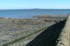
The Granton area extends along the south shore of the Firth of Forth. The area is fairly flat generally, but along the shore there is a strip of land close to sea level with quite a steep slope up to flat ground at a higher level. This is apparently the result of a change in sea level in prehistoric times, the slope forming a ‘raised beach’. The strip along the coast was at one time below water.
Along the waterline, particularly noticeable just to the east of Granton Harbour, are rock formations known as shale beds, studied by, among others, Charles Darwin when he was a student at Edinburgh University in the 1820s.
For many centuries, the area seems to have been quite desolate, with few people living there. The main use of the land seems to have been for farming and grazing animals.
The most notable historical event was the landing of English troops led by the Earl of Hertford in 1544, when Scotland was still an independent country. They went on to attack Leith, but was eventually defeated at the Battle of Ancrum Moor. This period in Scots history was referred to as the ‘Rough Wooing’, and started with an agreement in 1543 between the Scots and English that the recently born Mary Stuart would eventually marry Prince Edward of England and that the two countries would unite. The Scots Parliament did not agree and several years of conflict resulted.
Unlike many places, including areas that are now part of Edinburgh, there was no long-standing village or settlement in the area. The parish church for Granton was at Cramond – some distance away to the west.
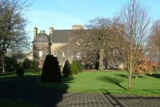
However, there were a few large houses, such as Granton Castle and Caroline Park.
The eastern part of the area, at Trinity, gradually developed into a residential area in the early nineteeenth century when large detached houses were built on the higher ground in Trinity and, from the 1820s, nearer the sea in Trinity Crescent.
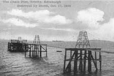
On the waterfront, a chain pier was built at Trinity in 1821. This was a time when steamships were becoming more common, and they were much easier to steer than sailing ships. It was therefore easier for them to use quite a lightly built pier – sailing ships generally were pulled into their moorings by capstans turned by a large number of men, which needed a substantial stone pier. For some years, steamers provided services from the Chain Pier to various ports in Fife, and to places like Stirling, but also to Aberdeen and London. Until the 1840s, when long distance railways were built, the only alternative way to get to Aberdeen or London would have been by stagecoach.
A great change in the area took place in the 1830s. The Fifth Duke of Buccleuch, who owned much of the land in Granton, constructed a major harbour. This was built in stages, the first part opening in 1838. Granton Harbour could be used at all states of the tide, unlike the existing harbour and docks at Leith.
The Duke also had other business interests, including coal mines in Midlothian and an involvement in some of the early railways in the Lothians. A railway was built, at first from Scotland Street, Edinburgh, to Trinity but soon extended to Edinburgh city centre at the south end and Granton Harbour at the north end.
In 1850, a train ferry was introduced, running between Granton and Burntisland. Railway wagons were run onto the ferries at one port and run off at the other, with no need for them to be unloaded for the voyage. Separate vessels carried passengers across the Forth.
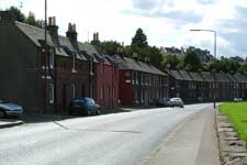
Along with Granton Harbour came houses, at first for construction workers and later for employees at the harbour. Some of these still exist, the two-storey brick houses on Lower Granton Road, known at one time as East Cottages. (The West Cottages immediately west of Granton Square were demolished many years ago.)
Immediately south of the harbour, a square was built, called Granton Square. A new road, now Granton Road, connected it with what is now Ferry Road and access to Edinburgh via Canonmills, and the existing road along the shore to Leith via Newhaven formed the route to the east. On the east side was a substantial hotel, Granton Hotel, with stables and a ‘tap room’, and on west side buildings that were used as offices for the harbour. These, and the Harbour itself, were built with local stone from Granton Quarry.
Over the years, houses were gradually built in the area. Some of them were tenements for working people, along Lower Granton Road and up Granton Road, but there were also some much grander houses constructed particularly in the Trinity area.
Schools and churches were established to serve the population.
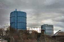
A range of industries developed in the area over the years, some connected with the harbour such as shipbuilding and some connected with the fishing industry based at Granton Harbour which was a substantial one. A large gas works was built, which opened in 1902. Later, some engineering businesses such as Bruce Peebles (who made electrical equipment) and United Wire Works (who made wirecloth) came to the area and also some surprising ones such as car manufacture.
At the start of the twentieth century, much of the area was still used for farms and nurseries – market gardens supplying Edinburgh and Leith at a time when long distance transportation of fresh produce was still difficult.
Communications were gradually modernised, with electric trams, run by Leith Corporation, reaching Granton Square in 1909. They replaced a service run by horse-drawn buses. After Edinburgh and Leith amalgamated in 1920, the Leith and Edinburgh services were combined.
After World War I, the boundaries of Edinburgh were extended, by the amalgamation of Leith with Edinburgh in 1920 and by the city taking in parts of Midlothian. The whole of the Granton area became part of the city, at a time when there was a great need for new houses. At this time, new legislation made it much easier for local authorities to build houses for rent and a large area of housing was built by Edinburgh Corporation, starting at Boswall Parkway and eventually including West Granton, East and West Pilton, Muirhouse and Pennywell.
Houses were also built in various parts of the area for owner-occupation and for private rent, for example by Gumley in the Boswall and Crewe Road North areas.
The end of the twentieth century saw major changes, with traditional industries closing, the harbour ceasing to be a centre for fishing and cargo vessels and generally fewer local places of work. A large part of the harbour was reclaimed to provide land firstly for commercial use but more recently for other developments.
Some of the more ambitious plans for developing the area have not turned into reality, but many new flats have been built at and near Granton Harbour and to the south west of it, along with some new roads and other improvements.
You can find out much more by exploring this website either by using the drop-down menus at the top of each page or from the home page.

