The first Granton school
| Built | Architect |
|---|---|
| 1840s? | ? |
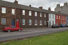
This school seems almost certain to have been the first in Granton, and although it now forms part of the terrace of two-storey cottages on Lower Granton Road (originally called East Cottages) it was built before them. The school was presumably built by the Duke of Buccleuch to provide education to the children of his employees at Granton Harbour, and is built of similar bricks, produced in the Granton area, to the adjacent houses. (The brickwork has since been painted.)
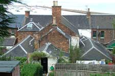
It appears on an 1852 Ordnance Survey map as a rectangular building on the south side of Lower Granton Road, with a small projection to the rear, but by 1876 has had a much larger rear extension added (which is still in existence) making a T-shaped building extending well back from the rear line of the houses that were next to it by then. The two side entrances to the school, which were at first in the open air next to the building, were incorporated into the adjacent buildings. On both maps, a wall divides the ground behind (south of) the school building, no doubt into separate playgrounds for girls and boys.
In 1885 a new school was built at West Granton Road by Cramond Parish School Board but it may not immediately have replaced the Lower Granton Road school, which is still marked as a school on a Bartholomew 1893 map.
In later years it apparently was used as a factory for making and repairing fishing nets but was subsequently altered to form a number of houses.
The links below are to pages on the National Library of Scotland website. On the two Ordnance Survey maps, which are at a scale of 5 feet to the mile, the school is at the top right corner. On the Bartholomew map, at a smaller scale of 15 inches to the mile, it is near the centre. The NLS site lets you zoom the maps to see detail.

